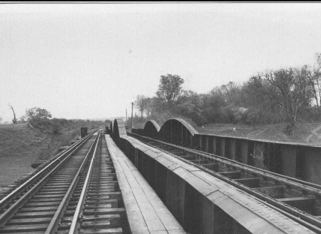
Old maps and photographs offer several ways into Shrawardine’s history. The records below range from a township map dated 1728 to photographs of the railway crossing in 1948 and 1954. Some can be viewed online; others are catalogue references for further research. Township map record ↗; 1948 aerial photograph ↗; 1954 bridge photograph ↗.
Early maps and views
The Shropshire Historic Environment Record lists J. Dugharty’s Map of the Township of Shrawardine, 1728, under reference SSA245. This is a useful reference for an enquiry about early mapping of the village. The original map has not been inspected for this guide, so no detailed interpretation of its buildings or boundaries is offered here. Shropshire HER, source 17 ↗.
John Ingleby’s 1796 watercolour, Sh(r)awardine, provides a different kind of record. Held by the National Library of Wales as PD9243, it depicts ruined walls with buildings behind them. It is an artist’s view, rather than a measured plan. Image and collection details ↗.
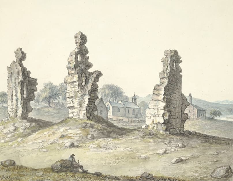 John Ingleby, Sh(r)awardine, 1796. National Library of Wales, PD9243. Public domain.
For the site’s history and archaeological evidence, see Shrawardine Castle.
Exploring Ordnance Survey maps
Historic England’s archive records a photographic copy of Ordnance Survey sheet 320, in two sheets, with location pointers at Shrawardine and Shrewsbury. The record gives 1817–1827 as the survey dates, but does not give a publication date. Its reference is AO1320. Historic England Archive ↗.
A later map is available online: Ordnance Survey sheet 033/NE, covering Shrawardine and neighbouring places ↗. The reproduction on Wikimedia Commons is sourced from British History Online and catalogued 1883–1895. That range should not be read as a precise survey date.
For wider exploration, the National Library of Scotland’s map guide ↗ links to digitised mapping of England and Wales and tools for finding, comparing and annotating maps. When comparing editions, note the sheet number, scale and any survey, revision and publication dates separately. Keep a record of which edition supports an observation.
Historic photographs: the railway and river
Britain from Above holds an aerial photograph of the railway bridge over the flooded River Severn near Little Shrawardine Farm, dated 14 January 1948. It can be viewed under reference EAW012696. View the aerial photograph ↗.
The photograph at the top of this page was taken by Ken Brockway on 25 April 1954. His caption identifies the crossing as part of the former Shropshire and Montgomeryshire Light Railway and associates the photograph with a Railway Correspondence and Travel Society visit. Brockway’s photograph and caption ↗.
Read more about the crossing in our guide to the River Severn at Shrawardine.
Other archive collections
The Museum of English Rural Life’s Fowler catalogue lists three photographs of machinery demonstrations at the International Tractor Trials at Shrawardine, reference TR FOW/PH3/21. The catalogue dates them approximately to the early 1920s. This is a lead for further research, rather than a confirmed date for the event. Fowler catalogue, PDF pages 110–111 ↗.
The castle’s Historic Environment Record also lists ground-level and aerial photographs. Examples include a Cambridge University Collection of Air Photos image dated 20 December 1966, reference CUCAP AQI70, and photographs by Carole Ryan dated January 1983. These references can help identify material when making an archive enquiry. Shropshire HER, sources 2 and 15 ↗.
For related local context, explore St Mary’s Church and the History section.
Image credits and reuse
The bridge photograph is © Ken Brockway, reproduced from Geograph photograph 340064 ↗ under Creative Commons Attribution–ShareAlike 2.0 ↗. The watercolour is John Ingleby, Sh(r)awardine, 1796, National Library of Wales, PD9243, reproduced from the public-domain image on Wikimedia Commons ↗.
The 1948 aerial photograph and other archive material are linked rather than reproduced here; permission to reproduce those images has not been established for this guide.
Sources & further reading
- Shropshire Historic Environment Record, Shrawardine castle and settlement remains, PRN 00052 (MSA125), source list including SSA245, via Heritage Gateway. Accessed 18 September 2026. ↗
- Historic England Archive, Ordnance Survey Sheet 320, Shropshire, two sheets with location pointers at Shrawardine and Shrewsbury, AO1320; survey dated 1817–1827. Accessed 18 September 2026. ↗
- Ordnance Survey, Map of Shropshire, sheet 033/NE, catalogued 1883–1895. Wikimedia Commons reproduction sourced from British History Online. Accessed 18 September 2026. ↗
- National Library of Scotland, Maps, family-history research guide, updated 23 January 2026. Accessed 18 September 2026. ↗
- John Ingleby, Sh(r)awardine, 1796, National Library of Wales, PD9243. Public-domain reproduction and collection metadata on Wikimedia Commons. Accessed 18 September 2026. ↗
- Britain from Above, Railway bridge over a flooded River Severn near Little Shrawardine Farm, Little Shrawardine, EAW012696, 14 January 1948. Accessed 18 September 2026. ↗
- Ken Brockway, Railway Bridge across River Severn (1954, now dismantled), 25 April 1954, Geograph photograph 340064, CC BY-SA 2.0. Accessed 18 September 2026. ↗
- Museum of English Rural Life, University of Reading, John Fowler & Co. archive catalogue, TR FOW/PH3/21, photographs at the International Tractor Trials, Shrawardine, catalogued as early 1920s; PDF pages 110–111. Accessed 18 September 2026. ↗
awardine,_1796.jpg)
